Saving the Moai on Easter Island

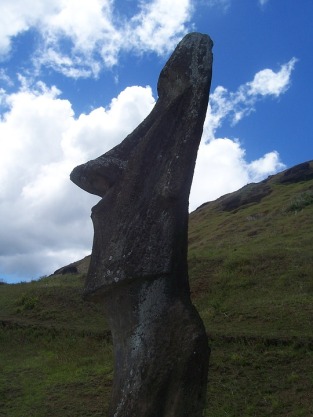
THE GIANT STONE HEADS on the island of Rapa Nui (Easter Island), Chile, have captured the imagination of countless explorers, dreamers and scientists. Hundreds of monoliths of solid volcanic rock provide indestructible evidence of man’s mastery over his environment. They hint at great feats of engineering and the ingenuity of men. Up close, the statues show their vulnerability. Their sharp features have eroded, growths invade their surface and many lie in piles of rubble.

A combination of natural and human forces threatens the statues, which are called moai in the native Rapa Nui language. To combat these forces and save the moai, teams of native and international scientists are working on reconstruction and restoration projects.

At 400 to 1000 years-old the moai are young compared to other archaeological monuments in the Americas, but the very properties of the stone that make them ideal for carving also make them susceptible to rapid deterioration. Nearly all of the statues were carved in the Rano Raraku Quarry located on the northeast corner of the island. Many of the statues never made it out of the quarry and remain there today in varying stages of completion. The red scoria stone used for headpieces found on some of the moai came from solidified froth of volcano lava.

These soft, volcanic rocks are particularly vulnerable to erosion from Easter Island’s relentless wind and rain. “When the stone is wet, the clays present in it absorb moisture and expand; as the stone dries, they contract. The internal stress of these repeated expansions and contractions results in microfissures within the stone which serve as channels for water migration and its corrosive effects,” wrote A. Elena Charola in a 1994 publication of the World Monuments Fund. Another natural process that weakens the stone is the growth of algae and lichens. Not only do they trap water—which plays a part in the wet/dry cycle of the stone—but they also eat away at the stone surface.

While nature has been hard on the moai, man has been even harder. The human toll on the statues has been immeasurable. Starting with the carvers themselves—who not only knocked over their beloved statues but also beheaded some of them—people have had a sort of fatal attraction to the heads. Archaeologists estimate that between 1,100-1,500 AD islanders meticulously carved approximately 900 statues and their accompanying stone platforms from the island’s soft volcanic rock. Most likely the carvers belonged to family groups who were competing with each other to produce larger and larger moai. The biggest statue, named el Gigante, weighs between 145-165 tons and would reach 71.93 feet high if it were standing. But for reasons unknown el Gigante was never raised and remains in the Rano Raraku Quarry.

moai2

The islander’s obsession with larger and more impressive moai wreaked havoc on the environment. More and more trees had to be cut down to provide scaffolding for the statues and to build wooden sleds to move the statues overland. By the time Dutch explorer Jacob Roggeveen landed on the island on Easter Day in 1722, he found a desolate landscape void of trees or bushes over 10 feet high with no birds, bats or lizards. The people were hungry and fighting amongst themselves. Sometime after contact with the outside world, the islanders knocked over and destroyed most of the moai probably as a result of clan warfare. Contact with the outside world brought new diseases, a new form of religion and kidnappings for the slave trade. By 1877 the native population of 15,000 had declined to a mere 111.

The relationship between man and moai is complex, and similar to the admirers of the past, modern-day man’s fascination with the statues has produced both positive and negative results. As the island’s only industry, tourism provides a way to make a living for the most remote civilization on Earth. Unfortunately the occasional unscrupulous visitor has encouraged islanders to sell broken parts of the statues for souvenirs. Further damage comes from foreigners and locals alike who defile the moai with graffiti or accidently step on fallen rocks or buried petroglyphs. In spite of admonishments from local tour guides, some visitors touch the statues or climb on their platforms. In the early 90s, the World Monuments Fund, reported an increase in graffiti by 20% in a two-year period.

At 400 to 1000 years-old the moai are young compared to other archaeological monuments in the Americas

Locals warn that the island is not prepared to support the number of tourists that come. According to Easter Island officials, in just 3 years tourism doubled from 22,000 visitors in 2003 to more than 50,000 in 2007. Not only does increased tourist traffic stress the monuments, masses of visitors strain the island’s resources as they struggle to deal with piles of trash and to meet the increased demand for food and water.

Although Easter Island has been an official historic monument and national park since 1935, it took until 1966 for the government of Chile to actually send a small staff to the island. The Rapa Nui National Park takes up nearly half of the island and includes nearly all of the moai sites. In 1995 UNESCO named Easter Island to its world heritage list of the world’s greatest monuments. The world is so captivated by the moai that Easter Island was a finalist in the New 7 Wonders of the World campaign in 1997 where 100 million people from around the world voted on the Internet for cultural heritage sites.

One of the first scientists to realize the archaeological and cultural significance of the site was University of Wyoming Professor William Mulloy, who tirelessly campaigned UNESCO for support to study the island’s monuments. During his first official mission to the island in 1966, Mulloy and Gonzalo Figueroa led a team of experts who developed a plan for studying, conserving and restoring Rapa Nui’s cultural treasures. What followed was a series of projects with international support that restored moai and their platforms and eventually the Orongo village from 1974-1976.

moai

In 1986 Chile’s Centro Nacional de Conservación y Restauración worked with UNESCO to investigate possible treatment plants to prevent or slow deterioration of the statues. They chose a moai at Hanga Kio’e that had been re-erected but was highly deteriorated. After spending several months drying out under a protective tent, the moai was cleaned of all growths and dirt. The restoration experts applied a consolidation treatment to harden the stone and prevent erosion and a hydrophobization treatment to prevent water from seeping into the stone. Although these treatments have worked so far, they do not provide permanent protection of the moai and need to be reapplied periodically.

From 1992 to 1996 a team led by University of Chile archaeologists professor Claudio Cristino and professor Patricia Vargas completed an ambitious reconstruction project of ahu Tongariki, the largest and most impressive ceremonial center on Easter Island. Both Cristino and Vargas had extensive knowledge of the island’s monuments. From 1977 to 1996, they were part of the Easter Island Archaeological Survey, a University of Chile research program that recorded more than 20,000 archaeological sites and features. At its peak, the ahu Tongariki measured nearly 220 meters long, with a central platform measuring 100 meters and a wing on either side. A total of 15 statues weighing between 40 to 90 tons once stood on that platform.

The ahu Tongariki was leveled in 1960 by an earthquake that destroyed most of the central and southern regions of Chile. That deadly quake, some 3600 kilometers away, triggered a powerful tsunami that swept over the four meter high monument wall destroying the ahu platforms and dragging the statues inland. The broken moai were covered by tons of rocks from the destroyed platforms.

Fans of Easter Island feared that this great archaeological treasure was lost forever. Then in 1991 a Japanese company donated a crane to move the statues and partial funding for reconstruction costs. Cristino and Vargas led the reconstruction project which lasted 4 years and took a team of 50 people, most of them islanders themselves. Each rock fragment had to be studied, drawn and then input into the computer.  Due to the soft nature of volcanic tuft, the rocks were in poor condition.

The team covered the moai with huge plastic tents and once they were dry, the statues could be moved without falling apart. “The first statue that went up was about 45 tons [and] went up in a few days,” Cristino explains. Painstakingly the team reconstructed the statues and placed them on their ahu platform. The result is a monument as tall as a five story building with 15 Moai and their topknots called pukaos.

A combination of natural and human forces threatens the statues

“We started from zero, little by little, trying to put this back together,” Cristino explains. “We used historic photographs and maps. Our main goal was the reconstruction of a largely destroyed monument.”  For his mostly local staff, the project was a revelation. “Little by little [they] realized what their ancestors did was incredible. Their sense of pride was enormous.”

UCLA archaeologist Jo Anne Van Tilburg considers herself to be “a friend of the family” to the moai. Since 1982 she has surveyed the moai compiling what she calls “biographies” of 1045 sculptural objects that include full or partial moai. Van Tilburg runs the Easter Island Statue Project (EISP) with Co-director Cristián Arévalo Pakarati, a native Rapa Nui artist and surveyor. “The statues today do not look the same as when I saw them in 1982,” she says. “I could see the change over time.” Van Tilburg appealed to the Archaeological Institute of America to fund a preservation project to develop treatments for the fragile stone. With the grant, EISP installed a weather monitoring station near two moai in the Rano Raraku quarry. For the first time, scientists will be able to record fluctuations in wind, moisture and temperature near a statue and observe how the stone reacts to changes in weather. Van Tilburg says with this information, the team will be able to develop a treatment plan that could be used not only on the sample moai, but also on the 400 other statues that reside in the quarry.

As part of the same project, Research Associate Christian Fischer of UCLA and Conservador Jefa Monica Bahamondez P. of Chile’s Centro de Conservación y Restauración used a portable sprayer to apply two different types of water-repellent solutions to the test statues. Although the mixture will take several months to evaporate and dry, the team could see that it was already working when they poured water on the monuments and watched the water droplets run off the stone.

To better educate and manage visitors to Easter Island, the Corporación Nacional Forestal de Chile (CONAF)—the government agency that manages all of Chile’s national parks and reserves—opened a sustainable visitor center in May of 2011. The center is located at the entrance to the Orongo Ceremonial Village, which is one of the most visited archaeological sites on the island. “Easter Island is a landmark in the tourism world and that is why we need to work hard to preserve its resources as well as offer all kinds of information and education to its visitors, both national and international,” says CONAF Executive Director Eduardo Vial Ruiz-Tagle.

The moai of Easter Island tell different stories depending on the listener. For the islanders, they tell the story of their ancestors. For scientists they tell the story of a society gone awry and for the rest of the world they tell the story of human ingenuity.  “Without something to remind us of the achievements or problems of the past, we don’t pay attention,” says Jo Anne Van Tilburg. To make sure that we continue to pay attention, scientists and conservationists are working to protect the statues for the generations of listeners in the years to come.


Published in Americas magazine, November-December 2011, by Chris Hardman


Unraveling an Inca Mystery

AT LAGUNA de Los Condores near Chachapoyas in Peru, laborers cut down trees to gather lumber for a hacienda under construction. As they watch a tree fall, one of the men glances across the lake and spies a painting on a cliff face. Motivated by the possibility of discovering gold, the group treks around the lake until they find a site adorned with primitive rock paintings that lead the way to seven, above ground burial chambers.

They have discovered a burial site for the Chachapoyas, an isolated civilization that ruled the Northeastern lands of Peru from 700 AD until the Incas conquered them in the 15th century. The burial chambers yield ancient artifacts, ceramics, textiles, and more than 200 mummies.

But these men aren’t interested in the historical significance of their find. With gold in mind, they hack into the mummies and loot the site for several months until the police shut down their operation.

Eventually the valuable artifacts are recovered and the site is handed over to Peruvian archaeologist Sonia Guillén and her colleague Adriana von Hagen. While much of the scientific world marvels at the discovery of 200 mummies in their funerary garb, a smaller group of scholars turns their attention to what else is in the burial chambers— 32 well preserved knotted strings called khipu. Is this the clue they are searching for? Were the ancient inhabitants of Peru finally speaking to them from the past?

The mystery in the Andes is how the Inca—the largest empire in the Americas until the Spanish came in 1532—could rule and administer an area covering thousands of miles with no form of written word. At the peak of their power in the early 16th century, the Inca state stretched along the Andes from southern Colombia through Ecuador, Peru, and Chile, over to Argentina, and into the Amazon basin.

The rulers in Cusco kept detailed records of births, marriages, tributes, religious rituals, and other activities throughout their empire using knotted and dyed strings. For the last 500 years, historians and scientists have been trying to solve the mystery of the khipu and decode the information within. The most recent discovery of 32 khipu at Laguna de los Condores a decade ago, has provided valuable clues to the mystery of this ancient form of communication.kipu

The word khipu is from Quechua, the language of the Inca, and means knot. A khipu is made of cotton or sometimes camelid fiber and varies in color from white to brown or green. When wrapped for storage, they resemble a string mop, but when they are spread out, they reveal a complex array of knots and strings. Most have one main cord on a horizontal plane with pendant cords hanging from it.

The pendant cords may have their own attachments called subsidiaries. Some khipu have as many as 10 or 12 levels of subsidiaries. Knots are strategically tied on the pendant cords and subsidiaries to represent numerical values.

Most of the 700 khipu in existence today are from the time of the Inca—the early 1400s to the early 1500s— but it’s hard to know exactly where they came from because most were dug up by looters and sold to museums and private collections.

Much of what we know about the khipu and the type of information it stores comes from the Spanish chroniclers. Through drawings and text they described how the khipumakers or khipukamayuqs kept records on all aspects of Inca life including census data, landholdings, and legal proceedings.

“If one reads the chronicles you continually come across references to the khipu whether they are talking about an Inca myth or Inca dynasty or social structure,” says Gary Urton, a Harvard professor and creator of the Khipu Database Project.

“Repeatedly one comes upon references that say all the Inca really knew was recorded in the khipus.” Urton refers to a translation from one of the most well-known Spanish chroniclers, Garcilaso de la Vega who describes khipu practices:

Although the quipucamayus [khipu-makers/keepers] were as accurate and honest as we have said, their number in each village was in proportion to its population, and however small, it had at least four and so upwards to twenty or thirty. They all kept the same records, and although one accountant or scribe was all that would have been necessary to keep them, the Incas preferred to have plenty in each village and for each sort of calculation, so as to avoid faults that might occur if there were few, saying that if there were a number of them, they would either all be at fault or none of them (1609-1617).

The chroniclers relied on the khipukamayuqs to give them information about the Inca state, especially in the early days of the conquest when the Spaniards were trying to understand the history of the Inca and the vast territory they controlled. In a 2003 article in Latin American Research Review, Galen Brokaw, a professor of romance languages and literature at the University at Buffalo in New York, describes a passage from the Discurso sobre la descendencia y gobierno de los Incas signed by a Fray Antonio in 1608,

“The viceroy Cristóbal Vaca de Castro gathered together the oldest inhabitants of Cuzco and the surrounding area and asked them to give an account of their origins and history. The responses that he received varied greatly and often contradicted each other. Perceiving the frustration of the Spaniards, these ancianos (elders) suggested that they seek out the old khipukamayuqs. They explained that prior to the arrival of the Spaniards, Atahualpa had attempted to revise Inca history by burning all the khipu he could find and killing the khipukamayuqs. Those that escaped had been hiding in the mountains ever since. The viceroy sought out these khipukamayuqs and had them brought to Cuzco with their khipu. He then posed the questions to them, and had their accounts translated and transcribed.”

Another prolific chronicler named Felipe Guamán Poma de Ayala included drawings of khipu in his book Nueva corónica y buen gobierno (c. 1615). He depicts treasurers with khipu, native officials carrying khipu, and a lord in front of his warehouse with an accountant and a khipu. One drawing shows a rolled up khipu—with the Spanish word carta (letter) above it— in the hands of a chasqui, one of the long distance runners the Inca used to deliver messages throughout their sprawling empire.

What puzzles khipu scholars is that although the Spaniards relied on the khipu, they made limited efforts to understand them. Galen Brokaw explains that because the Spaniards came from a society that used alphabetic writing to communicate, they found it hard to recognize a series of knots and strings as an important form of communication. As a result, they failed to preserve or study the khipu to the same extent they did with the pictographic texts of the Maya and Aztec civilizations.

Gary Urton says that the Spaniards deemed alphabetic writing to be a superior form of communication to the “primitive” khipu, so they were relatively disdainful of it. He laments that although there are about 2 dozen Spanish transcriptions of the khipu, researchers have yet to find the “Rosetta khipu” that would provide a match between a transcription and a khipu.  “The wildest dream of the khipu student is to find the ‘Rosetta khipu,’ ” he says.

The big challenge is how do you move from classification and structure to meaning and some kind of interpretation?”

In 1996 an amateur historian from Italy claimed to have found what Urton sought when Clara Miccinelli, a descendant of Neapolitan nobility, announced that her family archives contained a khipu along with a corresponding Spanish translation. But because she has granted the international scientific community only limited access to the materials, khipu scholars are skeptical of the document’s authenticity and do not include it in their compendium of khipu knowledge.

Perhaps because the Spaniards didn’t quite understand the khipu, they destroyed many of them and even declared them “ungodly.” So as the khipukamayuqs died, their knowledge of the khipu died with them. It would take nearly 500 years for a serious study of the khipu to begin. Early in the 1920s Leland Locke, an archaeologist at the American Museum of Natural History in New York, began his quest to decipher the code of the khipu.

His groundbreaking discovery came when he realized that the top cords of the pendants he was studying recorded the sum of the values on the pendants joined together by the top cords. He and other Andean scholars declared the mystery of the khipu solved: they were simply a series of calculations represented by knots on strings.

Interest in the field of khipu research resurfaced in the 1960s when mathematician Marcia Ascher and archaeologist Robert Ascher began their analysis of 191 khipu. “There is a logic to the khipus so that the colors of the cord, the spacing of the cords, the places the cords are attached, all of these things carry meaning in a symbolic system,” Marcia Ascher explains.

In their book Mathematics of the Incas: Code of the Quipu, published by Dover Publications in 1981, the Aschers concluded that in addition to arithmetic, the numbers on the khipu stood for non-quantitative information that could include labels for names of people or places.

After the Aschers published their book, textile expert William J. Conklin added yet another layer of complexity to the khipu. An architect by trade who had turned his focus to the structure of Andean textiles, Conklin drew attention to subtle differences in how the knots were tied.

Some of the knots were tied to the left, while others where tied to the right. There were left-hand knots and right-hand knots along with left-hand spins and plies and right-hand spins and plies. Conklin suggested that not only was the placement of the knots important, but perhaps the direction the knots were tied was important as well.

The wildest dream of the khipu student is to find the ‘Rosetta khipu.”

In the early 1990s anthropologist Gary Urton began his study of the khipu. “They seemed to be the device the Inca made and used that encoded all of their most complex and precious information,” Urton says. After spending a year with a weaving community in central Bolivia, he wrote the book The Social Life of Numbers: A Quechua Ontology of Numbers and Philosophy of Arithmetic, published by the University of Texas Press in 1997. Urton set out to analyze the khipu knot by knot and string by string.

By 2000, he realized the only way to manage all of the information he had collected was to create a computer database, so he hired software programmer Carrie J. Brezine, a spinner and a weaver with a mathematics background who has studied Quechua.

Currently the database contains information on 350 khipu with a total of 30,000 strings. With the aid of the database, Urton and Brezine search for patterns within and among the khipu. Recently the two researchers discovered a connection that links seven of the 22 khipu found at Puruchuco, an archaeological site just outside of Lima.

“This is the first time that we have seen information actually passing from one khipu to another,” Urton explains.  Until now each khipu seemed to record data in isolation, but the seven Puruchuco khipu were meant to be read together with the sums from one recorded on another.

“The big challenge is how do you move from classification and structure to meaning and some kind of interpretation,” Urton explains. “[My] greatest hope will be finding a connection between these structural characteristics of the khipu and information recorded in the Spanish documents.”

There is one group of khipus that Urton and other scholars believe they have deciphered. The largest khipu found by the workmen at Laguna de los Condores in Peru appears to be a calendar. It has 730 strings organized in to 2 groups (365 x 2), which Urton interprets as a two-year calendar.

“When you see strings organized like that you can say with some confidence, ‘I’m looking at a calendar,’” Urton says. “That means that each string can be translated into a day.”

The debate among current-day scholars centers on the question of whether the khipu is a form of writing. “If all they needed to do was record numbers, then you would have a system that was much more economical, such as one of just white cotton strings tied in a decimal hierarchy,” Urton explains, “but there is tremendous variation in terms of color, spinning and plying, and the directions of knots.”

In Signs of the Inka Khipu, published by the University of Texas Press in 2003, Urton suggests that each decision the khipukamayuq makes contributes to the information conveyed in the khipu.

Similar to a computer’s binary code, the making of a khipu involved 7 steps where an either or choice had to be made such as the spin and ply direction of the string (left or right) and the direction of the slant of the knot (like a Z or an S). With the additional choice of 24 variations of string colors, this system of communication could allow the khipukamayuqs to convey some 1,536 units of information (2 6 multiplied by 24), which is nearly double the amount of hieroglyphic signs the ancient Egyptians and Maya created.

If Urton’s theory pans out, the Inca will have created the only known three-dimensional written language, a task so complex that it would take 500 years for the rest of the world to even begin to understand it.

On the other hand, the Aschers present a different hypothesis. They suggest that instead of alphabetic writing like we use, the khipu contains concept writing that relies on numbers to convey information that is non-quantitative.

“Numbers in a certain layout are not magnitudes,” Marcia Ascher says. She explains that numbers can be used as labels. For example, a social security number or a driver’s license number is a label for a person, and if you put together a birth date, a telephone number, a zip code, and a social security number, you are telling the story of someone’s life.

In addition, familiar number patterns can be used to tell a story. Anyone who knows how to read the scoreboard of a baseball game, can tell the story of the game by reviewing the numbers alone. Ascher says that khipu have a multitude of number patterns and some are sums and some are not. The question is what do the patterns stand for? This method of using numbers to convey non-quantitative information is very different than what most societies are used to.

In a 2005 paper in Science magazine, Urton and Brezine suggested that just such an arrangement of knots used as labels is found on several of the Puruchuco khipu. Galen Brokaw comments, “For people like us who have alphabetic mentalities, the way we think about writing is conditioned by the medium that we use. The problem is that our alphabetic medium makes it difficult for us to understand the khipu.”

kipuAlthough most of the khipu that remain today are from the Inca,William Conklin points out that the khipu are only part of a 2000-year history of Andean textiles. He has conducted detailed analysis of a group of Middle Horizon khipus from a time period 700 years before the Inca.

“The Inca quipu form must have gradually replaced the more complex, colorful, but redundant and repetitive quipus of the Middle Horizon period,” he wrote in the Annals of the New York Academy of Sciences in 1982,  “The mathematics of the record-keeping Incas seems thus to have evolved from the art and ritual of earlier times.”

The promise of the khipu is access to information, statistics and historical accounts about the Inca, written by the Inca in their own voice. The beauty and complexity of this unique form of communication awes all who study it.

“One of the reasons we have not yet deciphered khipu is that we have not yet observed and recorded their information nearly carefully enough,” Conklin wrote in Narrative Threads: Accounting and Recounting in Andean Khipu, published by the University of Texas Press in 2002.

“In order to believe that the Andeans could actually read information from the complex khipu graphic fabric, it is necessary to remind ourselves of the amazement the Andeans expressed (at the moment of contact in Cajamarca) upon hearing the Spaniards miraculously verbalize language as they moved a forefinger along a line of our own subtle graphic code in the text of the Bible.”


Published in Americas magazine, September-October 2006, by Chris Hardman


Trophy Heads: Understanding the Nasca

AN EXPANSIVE collection of skulls from defeated enemies symbolized power in many early societies. The Jivaro tribe in the Amazon would remove skulls and shrink soft tissue to make “shrunken heads.”

The Munduruchu of Brazil decapitated fallen enemies and elaborately prepared the heads for display.

But the skulls collected 2,000 to 1,500 years ago by the Nasca civilization on the coast of Peru may have served a different purpose; scientists believe that figuring out that purpose could be important to understanding how civilization progressed in South America.

Originally discovered by the late Alfred Louis Kroeber—an American anthropologist from the University of California at Berkeley—the heads were collected from the Nazca Valley on the arid coast of southern Peru during expeditions in 1925 and 1926.

The heads were well preserved due to the area’s dry climate—they even retained traces of soft-tissue and hair. For the past 80 years the heads have been stored at the Field Museum in Chicago.

Scientists call the heads “trophy heads” because the heads have a hole in the front of them so that they can be hung from cords. Although portrayals of trophy heads were common in pre-Colombian ceramics, textiles and sculpture, the actual heads are hard to come by. Excavations in Peru have yielded only 150 of these heads so far.

Due to the lack of physical evidence, researchers look to pottery for clues as to the purpose of these heads. “Illustrations on some pots depict warriors and trophy heads,” says Patrick Ryan Williams, Associate Curator of Archaeological Science at the Field Museum in Chicago. “But there are also scenes that link trophy heads to agricultural fertility. Mythical creatures depicted on some pots carry trophy heads as well.”

trophy-head-skull-02

A 2001 study led by Professor Sloan R. Williams of the University of Illinois at Chicago showed that most of the 18 trophy heads housed at the Field Museum came from males between the ages of 18-25. Although that demographic suggests that the heads belonged to warriors, there were heads from women and children as well.

“As of 2001 we thought they were warriors,” says Ryan Williams. “That’s why this [recent] analysis we undertook was so critical to address this question: were these heads warriors?”

Researchers theorized that if the heads were trophies from war, they would have come from people who lived outside of Nasca territory.

In the 2008 study, led by Professor Kelly J. Knudson from Arizona State University, researchers compared samples of tooth enamel from 16 heads with the skeletons of 13 mummified bodies from the Nazca area.

By comparing the signatures of different forms of strontium, oxygen and carbon, the researchers could determine whether the two groups lived in and ate the same food produced in the same area.

“You are what you eat,” said Williams, “and the elements you consume become a part of your bones’ chemical signature.”

Because the comparison showed that the trophy heads came from the same population as the people who collected the heads, researchers believe that the heads did not come from expansionary warfare and were collected for some other purpose.

“For the Nasca, these heads could have a very different meaning. We need to keep in mind that heads turned into trophies may represent violence but, they may represent something else,” Williams says. “They me be a way to honor someone.”

Williams believes that understanding the Nasca culture is especially important because they were the predecessor to the Wari—one of the area’s most influential societies in South America who predated the Inca by 4 centuries.

“This small scale agrarian society was succeeded by an empire with regional authority,” Williams said. “For the first time people were governed by others who lived hundreds of miles distant. Understanding how this came about may help us better understand how these forms of government first emerged.”


Published in Americas magazine by Chris Hardman

The Staff God: An Ancient Mystery

IN 2003 RESEARCHERS in Peru’s Patavilca River Valley uncovered a 4,000 year-old-gourd fragment that appears to be the oldest identifiable religious icon in the Americas. The fragment bears the image of the Staff God, which was the main religious figure in South America until the Europeans arrived in 1532. Radiocarbon dating of the gourd to 2250 B.C. suggests that organized religion began in the Americas some 1,000 years earlier than previously determined.

Members of the Proyecto Arqueológico Norte Chico — Jonathan Haas of The Field Museum in Chicago, Winifred Creamer of Northern Illinois University, and Peruvian archaeologist Alvaro Ruiz — discovered the icon while they were collecting artifacts at a looted burial ground along the coast of Peru.

peru 1
Photo by Jonathan Hass, Courtesy of The Field Museum

“We did some surface collection and found this gourd fragment,” Haas said. “We looked at it and everybody’s jaw dropped and we said, ‘This has all the characteristics of the Staff God.’ ”

The drawing’s simplicity hinted at its age, and radiocarbon dating proved that this was the oldest image of the Staff God any researcher has uncovered so far. The team found a similar image also painted on a gourd at a nearby cemetery.

Worshiped as the creator, the Staff God appears in temples and artifacts throughout Andean cultures spanning thousands of years. The Staff God is recognizable by its fangs, splayed feet, and snake iconography. It is usually drawn with a staff in one or both of its hands and with snakes on a belt, on its hands, or coming out of its head.

The icon Haas and his team found has splayed feet, a fanged mouth, and holds a staff. The left hand is curved in the form of a snake.

“The Staff God undergoes change and evolution over the course of  2,000 to 3,000 years. It emerges during the Inca time as the Creator God,” Haas explained.

staff god
Drawing by Jill Seagard, Courtesy of The Field Museum

Haas and his colleagues were working 120 miles north of Lima in the Norte Chico region of the Peruvian Coast. The region’s four coastal valleys were densely populated between 2600 B.C. and 2000 B.C.

“To date, 26 major centers have been recorded in the Norte Chico region, all with monumental architecture, large-scale ceremonial structures, and complex residential and administrative architecture,” Winifred Creamer said. “It is a truly unique concentration of settlements anywhere in the Americas.”

In 2001, Creamer and Haas’ research team determined that around 2600 B.C. ancient Peruvians were building a complex city with pyramids at around the same time as the ancient Egyptians built their cities and pyramids.

Haas suggests that the Norte Chico region is the cradle of Andean civilization. The area would eventually give rise to the Inca empire, who during the height of their reign in the 1500s, ruled the largest empire on Earth.

The 2003 artifact pushes back the starting point for Andean religion and civilization and shows the Staff God at its most basic representation.

“What we’re seeing with Andean religion is although it has many different forms throughout its lifetime, it has a central core to it and that central core is arising in the 3rd millennium B.C.,” Haas said.


Published in Americas Americas magazine, July-August 2003, by Chris Hardman


Scientists find 4,500-year-old Dental Patient

A MAN FOUND under 12 feet of volcanic ash in Michoacán, Mexico, appears to be the earliest dental patient in the Americas.

Scientists estimate that approximately 4,500 years ago, he suffered through multiple painful procedures to have his upper front teeth filed down to make way for a denture, most likely the palate of a jaguar or wolf. T

he interdisciplinary and international team of researchers — led by University of Connecticut Professor Tricia Gabany-Guerrero — has uncovered clues as to whom this man was and why he would have undergone such extensive dental modification.

The man’s remote burial site in the volcanic highlands of west-central Mexico might have gone undiscovered if not for the interest of the local Purépecha residents from the  Comunidad Indígena de Nuevo Parangaricutiro. They discovered a series of vivid cliff paintings in the shadow of the Paricutin volcano and encouraged the scientific community to come and study them.

dental

The dental patient was accidentally uncovered while Gabany-Guerrero and her colleagues were excavating the site in search of the tools and paint used to produce the paintings. Much to their surprise they found the remains of a man wedged between two very large boulders.

“He really astounded us and his skull was oriented toward these paintings,” Gabany-Guerrero says.

Data taken from the skull, hand, leg and foot bones suggest that the man was between 28-32 years old, was in good health and stood 155 centimeters tall. Even though he lived in a harsh environment at an altitude of 8,860 feet, his bones show that he lived a leisurely life void of too much physical labor.

Researchers say that the dental modification, apparent lack of strenuous activity, and the location of the burial in front of a cliff wall indicate that the man held special status in his community.

According to Guerrero, dental modification was found in the Americas in the Late Post Classic period (1200-1441 AD), when people would insert turquoise or precious stones in front of their teeth to indicate status, but to find evidence of dental modification more than 1,000 years earlier is unusual. She suggests that the man held a ceremonial role in the community.

“You can imagine someone with filed down teeth and jaguar fangs sticking out,” Gabany-Guerrero says. “Certainly this would play up the ritual nature of who this person would have been in the society.”

The cliff paintings the man was buried under also provide clues to his identity. Very clear images show scenes of hunting, dancing and shaman in ritual poses.

“This is the first time that anything like this has been found in the Michoacan region,” says Gabany-Guerrero. “The iconography is giving us a window into a long period of time when this shelter was used for ritual purposes.”

She explains that archaeological remains of pre-ceramic societies are rare in this region and that this site might inspire more researchers to pay attention to a long-ignored area.

Currently the Comunidad Indígena de Nuevo Parangaricutiro is working with an NGO, The Mexican Environmental & Cultural Research Institute (MEXECRI), and Mexico’s Instituto Nacional de Antropología e Historia (INAH) to manage the site and guide tourists interested in viewing the artwork.


Published in Americas magazine,  January-February 2007, by Chris Hardman

Women Power in the Maya World

IN GUATEMALA’S Laguna del Tigre national park, the dense forest hides many treasures: endangered scarlet macaws flit among the treetops while rare jaguars hunt on the forest floor. Only recently has the world learned about one of the greatest treasures of Laguna del Tigre, a 2,500-year-old city that once stood at the crossroads of the ancient Maya world.

The archaeologists working on the site believe that this city can answer many of the lingering questions about political events in the Petén region during the Classic Period of Maya history.

The ancient city of Waka’—known as El Perú today—first came to the attention of the modern world after oil prospectors stumbled upon it in the 1960s. Ten years later Harvard researcher Ian Graham recorded the site’s monuments, and then in 2003 two veteran archaeologists, David Freidel of Southern Methodist University in Texas and Héctor Escobedo of University of San Carlos in Guatemala, launched a full-scale excavation of the site.

According to the historical record, Waka’ was inhabited as early as 500 BC. The city reached its political peak around 400 AD and was abandoned some 400 years later. In its heyday, Waka’ was an economically and strategically important city with tens of thousands of inhabitants who utilized four main plazas, hundreds of buildings, and impressive ceremonial centers.

Researchers say the key to Waka’s importance was its location between two of the most powerful Maya capitals—Calakmul to the north and Tikal to the east—and that in its history Waka’ switched its alliance back and forth between the two rivals. Researchers suggest that the city’s final choice of Calakmul may have led to the city’s demise at the hands of a Tikal king in 743 AD.

“We know a great deal about the ancient inhabitants of this site from their monuments,” Freidel said in an article for SMU Research. “The more than 40 carved monuments, or stelae, at the site chronicle the activities of Waká’s rulers, including their rise to power, their conquests in war, and their deaths.”

Waka’s location right by the San Pedro Mártir River, which was navigable for 80 kilometers in both directions, gave it great power as a trading center. In addition to the waterway, Freidel suggests that Waka’ controlled a strategic north-south overland route that linked southern Campeche to central Petén. Freidel calls Waka’ a “crossroads of conquerors in the Pre-Columbian era.”

One of the most intriguing people who inhabited Waka’ was a woman of uncommon power and status. The discovery and excavation of her tomb in 2004 by team member José Ambrosio Díaz  drew a lot of attention to the site.

“We knew that we were dealing with a royal tomb right away because you could see greenstone everywhere,” says David Lee, a Ph.D. candidate at SMU in Texas, who is investigating the Waka’ palace complex.  Greenstone is the archaeologists’ term for the sacred jade the ancient Maya used to signify royalty.  The team found hundreds of artifacts in the 3 ½ meters by 1 ¼ meters tomb that dates to some time between 650 and 750 AD.

There were several indicators that this woman was highly important and very powerful. Her tomb lay underneath a building on the main courtyard of the city’s main palace. Her stone bed was surrounded by 23 offering vessels and hundreds of jade pieces, beads, and shell artifacts.

Among the rubble, the researchers discovered a 4 x 2 inch high jewel called a huunal that was worn only by kings and queens of the highest status. Typically a huunal was affixed to a wooden helmet called a ko’haw that was covered in jade plaques. Carved depictions suggest that only powerful war leaders wore these helmets.

On the floor of the queen’s tomb near her head, researchers found 44 square and rectangular jade plaques they believe were glued onto the wooden part of the ko’haw.

The presence of this helmet in her tomb, has led the researchers to the conclusion that this queen held a position of power not typically afforded women of the time. “She may have been more powerful than her husband who was actually the king of El Perú,” Lee concludes.

Although the presence of the helmet identifies her as a warlord, archaeologists have found no evidence of Maya women physically fighting in battles. What they have discovered are images of women as guardians of the tools of war.

“The curation of the war helmet is one of the roles of royal women,” says the excavation’s bone expert Jennifer Piehl. She explains that Maya iconography describes how royal women curated these helmets and then presented them to their kings when they prepared for war.

David Freidel says that to the Maya war was more than just a physical act. It was also an encounter between supernaturally charged beings, and women had an active role in battle by conjuring up war Gods and instilling sacred magical power in battle gear.

Other symbols of royalty were the stingray spines found in the pelvic regions of the queen’s remains. Stingray spines are bloodletting implements that were used in ceremonies by Maya kings to let blood from their genitalia.

“The association between gender and power becomes blended because this person represents both kinds of power,” explains Lee. “As we learn more, we are discovering that what our culture considers traditional ideas of male-female roles, don’t hold true for Maya royalty.”

Researchers could also determine the importance of the woman by what was missing from her tomb. Some time after her burial, the tomb was opened up to remove her skull and femora.

“The cranium and crossed femurs is a very salient symbol in Maya ritual. It is the ancestor,” says Piehl. The Maya would take the skull and femur from an important ancestor and curate them in bundles. Maya images show how these bundles were used during ceremonies or were worn on the back of the ruler’s regalia.

“They are literally carrying their ancestor around with them,” says Lee. Researchers surmise that possession of a bundle gave legitimacy and power to the owners.

Once her status as a queen was confirmed, the question becomes which queen was she? A good candidate is a woman named Lady K’abel who lived during the Late Classic period and was the daughter of the King Jaguar Paw Fire of Calakmul.

Researchers interpret her marriage to king K’inich B’ahlam II of Waka’ as a savvy political move for Calakmul, because a royal marriage could forge a permanent political bond between the two cities. Unfortunately this marriage would not be a good political move for Waka’. Researchers suggest that this marriage was considered an act of betrayal by Tikal, which eventually led to Tikal’s defeat of Waka’ in 743 A.D.

A detailed portrait of Lady K’abel comes from a stela dated to 692 AD that was looted from Waka’ in the late 1960s. According to Maya expert and project epigrapher Stanley Guenter, inscriptions on the front face of the stel —curated by the Cleveland Museum of Art in Ohio —clearly identify the woman as Ix Kalmoote’ (lady warlord) Lady K’abel, princess of Calakmul.

“Mosaic mask pectorals formed of greenstone, shell teeth and eye whites, and obsidian pupils found in the interment are consistent with the image of Lady K’abel on Stela 34,” Lee and Piehl wrote in a recent paper.

“These attributes clearly demonstrate the royal status of the woman and an identification with Lady K’abel.” Radiocarbon dating of the queen’s remains will confirm whether the woman in the tomb lived during the same time period as Lady K’abel.

Another tomb, discovered by archaeologists Michelle Rich and Jennifer Piehl in 2005, tells the story of two women from an earlier part of Waka’s history, dating back to between 350 to 400 AD. The tomb contains the remains of two women between 25 and 35 years old, placed back to back, one of top of the other, with stingray spines near their groins.

The bottom woman, who was pregnant, lay face down and the top woman lay face up. Although the tomb is tiny by royal standards—90 cm wide, 1.2 m high, and 2 m long—Rich and Piehl believe that these women were high-ranking members of a royal family.

By analyzing their skeletal remains, archaeologist and osteoglogist Jennifer Piehl can tell a great deal about the status of these women in life.

“What we can say of the bones of the two Waka’ women is they were in excellent health—better than the majority of the Waka’ population—which fits with them being royal,” she says.

In addition, the lack of dental cavities suggests that unlike ordinary Maya, these women were treated to special foods including meat, fish, and fruit.

Further evidence of the elite status of these women comes from the seven ceramic vessels that accompanied them in death.  “The first thing we saw was the cluster at [their] feet of three gorgeous museum quality polychrome vessels,” Piehl recalls. The quality of the vessels and the symbols of royalty on them indicate that the women came from a royal bloodline.

Vessels of the exact same style were also found at Tikal in a similar set of tombs containing members of a royal dynasty that were probably killed by the great 4th century conqueror Siyaj K’ak’ from Teotihuacan.

According to the stone stelae from Waka’s main plazas, Siyaj K’ak’ also visited Waka’ in 378 AD on his way to conquer Tikal. “My conclusion is that these are members of the royal family that was in power before the arrival of Siyaj K’ak’,” Piehl says. Freidel calls Siyaj K’ak’s visit to Waka the city’s “first great experience as a crossroads of conquerors.”

Rich suggests that the women were sacrificed as part of a lineage replacement, where one invading ruler comes in and kills the current royal family to establish his family as the only royal blood in the kingdom.

“The king would have been the primary focus of sacrifice, but then the rest of the family would have to be exterminated in order to wipe out the entire ruling line,” Rich says.

To prove that hypothesis, the team is searching for a king from the same time period. In 2006 Hector Escobedo and Juan Carlos Melendez uncovered the tomb of a king under the site’s main pyramid, but more research needs to be done to fully understand who that man was.

Also in 2006, Rich and Varinia Matute, found another ruler, but he dates to approximately 550-650, a couple hundred of years later than the women.  “At this point we have two rulers and no connection to the sacrificed women,” Rich says. “El Perú is a huge site, and there is so much we can learn.”

Although the archaeologists involved with this project agree that further excavations of Waka’ have the potential to fill in some of the gaps of the political history of the region, the future of the Waka’ Archaeological Project is uncertain.

The site of Waka’ is located in Laguna del Tigre, the largest nature reserve in Central America which covers 48,000 hectares of such biologically significant habitat that in 1990 it was the first site named to the List of Wetlands of International Importance under the Ramsar Convention on Wetlands.

Despite its protected status, the forest of Laguna del Tigre is in danger due to illegal logging, slash and burn agriculture, and drug smuggling. Just as the forest is in danger, so is the city of Waka’ and any other archaeological treasures hidden in the forest.

To ensure the protection of Waka’ and the forest that surrounds it, Freidel developed partnerships with the Government of Guatemala, the Wildlife Conservation Society, and ProPetén to try and safeguard 230,000 acres of the forest. The group formed the K’ante’el Alliance, which means “precious forest” in Maya and refers to the mystical place where the Maya Maize God was reborn and where the Maya believe their civilization began.

The K’ante’el Alliance plans to protect the park by developing environmentally friendly sources of income for local communities that will celebrate the forest’s resources instead of destroy them.  The hope is that Waka’ and Laguna del Tigre will continue to share their hidden treasures for years to come.


Published in Americas magazine, May-June 2008, by Chris Hardman Map courtesy of the Waka Research Foundation


Queen of Maya Stelae

AN INTERNATIONAL team of archaeologists has uncovered the earliest known portrait of a Maya woman at the remote city of Naachtun in Northern Guatemala. The image was carved on a stela — a 6-foot high, 3-feet wide stone monument — and dates back to the 4th century A.D., making it 100 years older than any previous discoveries of Maya female portraits.

“I’ve worked in the Maya area a long time and I’ve never seen anything like it,” says team co-director Professor Kathryn Reese-Taylor of the University of Calgary in Canada. She suggests that this find indicates that Maya women held positions of power early in Classic Maya history, around A.D. 400, when the city of Naachtun was at its peak.

Although the stela was discovered in 2004, the team had to wait a year before they could excavate it. Project co-director Martin Rangel Guillermo, an archaeologist from Guatemala, found the stela sticking out of a looter’s trench. “He came to me and said, ‘I think we have something really important and I need you to come look at it,’ ” explains Reese-Taylor. They could see that the stela had intricate carvings on the side, but it was deeply buried inside the trench, and it would take much longer than the five days they had left to dig it out. The rainy season was rapidly approaching, and they knew they wouldn’t have enough time to study the stela before the site became inaccessible. So after consulting with the Guatemalan government, they made the tough decision to bury their incredible find and wait nearly a year until they could return and examine it.

Now the researchers are trying to figure out who this woman was and why was she important enough to document in stone? The first clues to her identity are in the portrait’s headdress, where a series of three glyphs spells out the name Ix Tzutz Nik or “Lady Completion Flower.” “What we’re looking at are a couple of possibilities that this is naming a historical queen or that this is naming a deity,” Reese-Taylor says. The name has shown up in three other early Maya sites, appearing on a stela and a pair of earrings. “We are going to have to have more information before we can conclusively state who this person is,” Reese-Taylor explains.

What the research team has concluded is that mythical or real, this Maya female was extremely important to the people of Naachtun. Stela typically portray kings, and if a woman is present, she is usually a mother or a wife, not a main protagonist. In addition stela were usually found on the outside of Maya buildings. “The fact that her stela was put inside this structure is something that is very rare,” Reese-Taylor explains. “That is reserved for really important historical figures or founders of dynasties.”

An attack from a neighboring city may explain why the stela was buried inside the temple. The glyphs on the back of the monument have been completely cut off and the sides hacked away. In times of conflict the ancient Maya would try and erase their enemies’ history by attacking stela and destroying glyphs. Perhaps the damage to the Lady Completion Flower stela was the result of such an attack, and afterwards the stela was moved to the temple where it was buried with a complete set of dedicatory offerings. Such burials were always associated with really important historical figures and females were not normally treated that way. “This represents an extraordinary event in the history of Naachtun and we were really lucky to find it,” Reese-Taylor says.


Published in Americas magazine, March-April 2006, by Chris Hardman